HUSAIN TRIVEDI
HOMEABOUTSKILLSEXPERIENCEEDUCATIONPROJECTSARTICLESCERTIFICATIONSCONTACT
OPEN TO OPPORTUNITIES
>_HUSAIN TRIVEDI

Combining remote sensing workflows and geospatial analysis with full-stack and DevOps foundations to build practical spatial solutions.

ORBIT_TIME: 02:27 PM UTC
24-Yr Study
Ahmedabad LULC (2000–2024)
~60.9%
Built-up Growth Tracked
5 Epochs
Classified & Analyzed

Navigation & Portals

  • // HOME
  • // ABOUT PROFILE
  • // GLS UNIVERSITY (BCA)
  • // CREOLE STUDIOS (DEVOPS)
  • // C.U. SHAH UNIVERSITY (AI)
  • // KHAGOLAM GEOINFORMATICS
  • // HARITA HIVE GEOSPATIAL
  • // PROJECTS CATALOG
  • // LOCALIT CASE STUDY
  • // MAKEPORTFOLIOS.COM
  • // URBANPULSE (LULC)
  • // RESUME & CREDENTIALS
  • // RSS FEED

Geospatial Hubs

  • // GIS ARCHITECTURE
  • // REMOTE SENSING
  • // GOOGLE EARTH ENGINE
  • // QGIS ENGINEERING
  • // ARCGIS ENTERPRISE
  • // GEOSPATIAL PYTHON
  • // WEB GIS PORTALS
  • // LIDAR & 3D SURFACES
  • // ARTICLES & INSIGHTS

© 2026 Husain Trivedi. All telemetry streams preserved.

GEOSPATIAL & CLOUD TELEMETRY SYSTEM

HUSAIN TRIVEDI
HOMEABOUTSKILLSEXPERIENCEEDUCATIONPROJECTSARTICLESCERTIFICATIONSCONTACT
OPEN TO OPPORTUNITIES
  1. HOME
  2. PROJECTS
  3. URBANPULSE
RESEARCH CASE STUDY

Urban Expansion & LULC Analysis (2000–2024)

24-Year Multi-Temporal Satellite Investigation of Urban Sprawl & Land-Cover Transformation in Ahmedabad City.

Earth Observation & Spatial Research

Ahmedabad Urban Growth Study
ArcGIS Pro · QGIS · Landsat (5, 8) · Digital Elevation Models
Download PDF Report
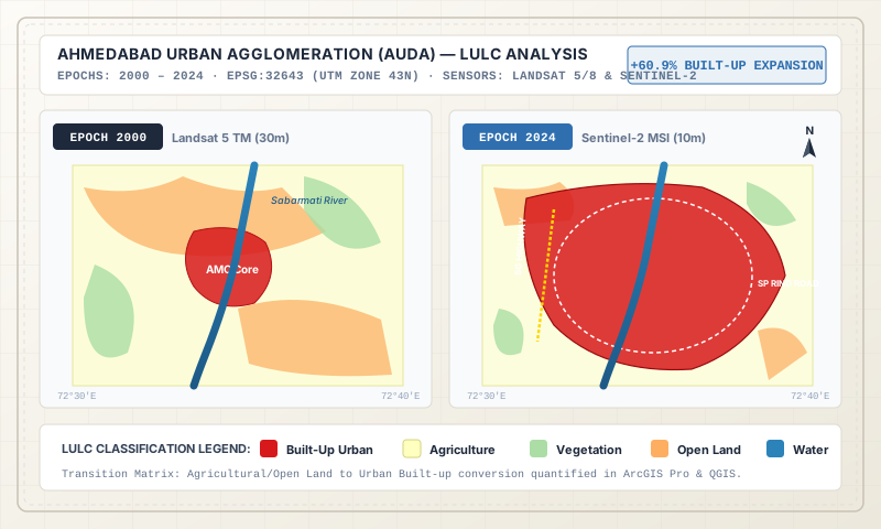
Multi-temporal Land Use Land Cover (LULC) classification map of Ahmedabad from 2000 to 2024 showing built-up expansion

1. Research Methodology & Multi-Sensor Imagery

This independent satellite investigation analyzed 24 years of rapid urban expansion, peripheral sprawl, and land transformation across Ahmedabad Municipal Corporation (AMC) and AUDA growth corridors. Using multi-spectral Landsat imagery (Landsat 5 TM and Landsat 8 OLI) across 5 strategic epochs (2000, 2008, 2015, 2020, and 2024), Husain conducted supervised classifications categorizing five principal LULC classes: Water, Vegetation, Open Land, Built-up, and Agriculture.

2. Quantitative Findings & Terrain Analysis

Key quantitative results derived from change transition matrices and spatial metrics:

  • Built-Up Sprawl: Quantified a cumulative built-up area growth of approximately ~60.9% over the 24-year period, predominantly expanding along western and southwestern radial arteries (S.G. Highway, SP Ring Road).
  • Vegetation & Agricultural Dynamics: Tracked the progressive conversion of peri-urban agricultural tracts into commercial and residential built-up zones.
  • Terrain Modeling: Extracted Digital Elevation Models (DEM), slope percentage maps, aspect, hillshade, and contour lines to assess topographical constraints on urban drainage.

3. Applied Training Integration

The research report was executed utilizing spatial modeling techniques taught during the Advanced Diploma in Geoinformatics at Khagolam Institute and supported by computational scripting methodologies taught during BCA studies at GLS University.

← Back to Projects CatalogExplore Khagolam Training →
>_HUSAIN TRIVEDI

Combining remote sensing workflows and geospatial analysis with full-stack and DevOps foundations to build practical spatial solutions.

ORBIT_TIME: 02:27 PM UTC
24-Yr Study
Ahmedabad LULC (2000–2024)
~60.9%
Built-up Growth Tracked
5 Epochs
Classified & Analyzed

Navigation & Portals

  • // HOME
  • // ABOUT PROFILE
  • // GLS UNIVERSITY (BCA)
  • // CREOLE STUDIOS (DEVOPS)
  • // C.U. SHAH UNIVERSITY (AI)
  • // KHAGOLAM GEOINFORMATICS
  • // HARITA HIVE GEOSPATIAL
  • // PROJECTS CATALOG
  • // LOCALIT CASE STUDY
  • // MAKEPORTFOLIOS.COM
  • // URBANPULSE (LULC)
  • // RESUME & CREDENTIALS
  • // RSS FEED

Geospatial Hubs

  • // GIS ARCHITECTURE
  • // REMOTE SENSING
  • // GOOGLE EARTH ENGINE
  • // QGIS ENGINEERING
  • // ARCGIS ENTERPRISE
  • // GEOSPATIAL PYTHON
  • // WEB GIS PORTALS
  • // LIDAR & 3D SURFACES
  • // ARTICLES & INSIGHTS

© 2026 Husain Trivedi. All telemetry streams preserved.

GEOSPATIAL & CLOUD TELEMETRY SYSTEM